Los Angeles Indymedia : Activist News
| About Us | Contact Us | Calendar | Publish | RSS |
|---|
|
Features • latest news • best of news • syndication • commentary Feature Categories IMC Network:
Original Citieswww.indymedia.org africa: ambazonia canarias estrecho / madiaq kenya nigeria south africa canada: hamilton london, ontario maritimes montreal ontario ottawa quebec thunder bay vancouver victoria windsor winnipeg east asia: burma jakarta japan korea manila qc europe: abruzzo alacant andorra antwerpen armenia athens austria barcelona belarus belgium belgrade bristol brussels bulgaria calabria croatia cyprus emilia-romagna estrecho / madiaq euskal herria galiza germany grenoble hungary ireland istanbul italy la plana liege liguria lille linksunten lombardia london madrid malta marseille nantes napoli netherlands nice northern england norway oost-vlaanderen paris/Île-de-france patras piemonte poland portugal roma romania russia saint-petersburg scotland sverige switzerland thessaloniki torun toscana toulouse ukraine united kingdom valencia latin america: argentina bolivia chiapas chile chile sur cmi brasil colombia ecuador mexico peru puerto rico qollasuyu rosario santiago tijuana uruguay valparaiso venezuela venezuela oceania: adelaide aotearoa brisbane burma darwin jakarta manila melbourne perth qc sydney south asia: india mumbai united states: arizona arkansas asheville atlanta austin baltimore big muddy binghamton boston buffalo charlottesville chicago cleveland colorado columbus dc hawaii houston hudson mohawk kansas city la madison maine miami michigan milwaukee minneapolis/st. paul new hampshire new jersey new mexico new orleans north carolina north texas nyc oklahoma philadelphia pittsburgh portland richmond rochester rogue valley saint louis san diego san francisco san francisco bay area santa barbara santa cruz, ca sarasota seattle tampa bay tennessee urbana-champaign vermont western mass worcester west asia: armenia beirut israel palestine process: fbi/legal updates mailing lists process & imc docs tech volunteer projects: print radio satellite tv video regions: oceania united states topics: biotechSurviving Citieswww.indymedia.org africa: canada: quebec east asia: japan europe: athens barcelona belgium bristol brussels cyprus germany grenoble ireland istanbul lille linksunten nantes netherlands norway portugal united kingdom latin america: argentina cmi brasil rosario oceania: aotearoa united states: austin big muddy binghamton boston chicago columbus la michigan nyc portland rochester saint louis san diego san francisco bay area santa cruz, ca tennessee urbana-champaign worcester west asia: palestine process: fbi/legal updates process & imc docs projects: radio satellite tv |
printable version
- js reader version
- view hidden posts
- tags and related articles
View article without comments Crystal Lake Recreation Area To Open Maybe Some Dayby Fredric L. Rice Wednesday, Sep. 13, 2006 at 9:47 AMfrice@skeptictank.org Crystal Lake -- when will it open?
Crystal Lake Recreation Area To Open Maybe Some Day
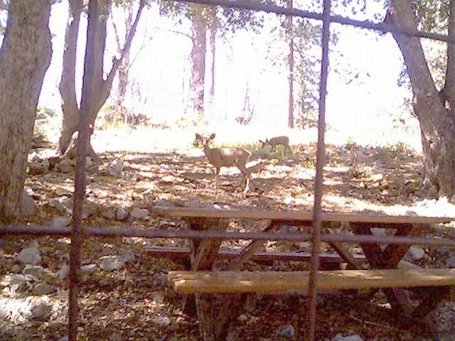
Fredric L. Rice, 09/Sep/06 Located in the Angeles National Forest, the Crystal Lake Recreation Area is the largest camping and hiking area in the San Gabriel Mountains. Since the Williams Fire and the Curve Fire, however, the area has been closed to the public due to health and safety hazards associated with the dead and dying trees. (Falling tree limbs, falling trees, floods, choking ash and dust are all problems that take time to rectify.) Over the past year considerable effort and expense has been put into re-opening the recreation area. Construction and repairs on Highway 39 heading up to the grounds has brought the highway up to standards for earthquake safety, and a considerable amount of blasting and earth moving has widened a notoriously narrow section of the highway, making the highway a two-lane road along its entire length. There are currently discussions under way within the City of Azusa looking into funding the repairs needed to open the Angeles Crest Highway (Highway 2) section of road that used to connect Highway 2 to Crystal Lake and from there to Highway 39 heading down to Azusa. That effort would require something near 30 million dollars and isn’t scheduled any time soon. Road building and repairs have a notoriously bad history for this mountain range since the geology of the area has resulted in whole sections of the highway sliding into the canyons below due to heavy rains and flooding. The history of the area, in fact, includes the waste of several tens of millions of dollars for a section of Highway 39 which had to be abandoned (included in the set of photographs provided) because the ground couldn’t be reworked to hold a road. There’s also been extreme problems with pollution caused by filthy humans that think dumping their garbage on the ground or out the window of their vehicles is normal behavior. With the proposed opening of the Crystal Lake Recreation Area and the future opening of Highway 2, the U. S. Forest Service would have to deal with disgusting pigs whose home lifestyles or cultures include thoughtless garbage dumping, spray painting of roads, signs, rocks, and trees, and throwing burning cigarettes out their windows. Since the Recreation Area and highway has been closed, the USFS has had to deal with such problems only up to mile marker 28 along the highway. Re-opening the area would mean that there would be an additional 12 miles of pollution, garbage dumping, spray painting, fires, homeless squatters, illegal Mexicans building shelters to live in, drugs, alcohol, people racing their cars, violent gangs, and all the usual problems that the USFS has to deal with, so I suspect the added burden has delayed the re-opening of the camping area. While the Crystal Lake area has been closed, groups of volunteers have been performing clean-up tasks which include felling dead and damaged trees (to remove the safety hazard) cleaning out flooded camp sites, and repairing the nature trails and hiking trails around the camping grounds. This has been hot and sweaty work however it had to be done due to the damage to the trails caused by fires, rains, and floods. One of the fully-completed hiking trails is the Lost Ridge Trail which has one end of the trail beginning at the bottom of Lake Road and the other end at the parking area at Deer Flats – a distance of less than a mile though the hike is a good one for views and examples of plant life. Another fully-completed hiking trail is Pinyon Ridge Trail which forks off of the heavily damaged Soldier Creek Trail. (Photographs from Pinyon is included in this set of photographs.) This trail forms a loop about a mile long which crosses a number of streams. The San Gabriel Mountains Trailbuilders repaired this trail not too long ago and while nearly all of it is still in excellent condition, the water at the start of the trail has allowed a considerable amount of vegetation to cover up the trail – the Trailbuilders will need to return to clear that once the Recreation Area opens up again. There’s one other trail that forms a loop that’s been completely rebuilt and otherwise repaired, the name of which I can’t recall. That trail is about 1.5 miles long and starts and ends at the main road heading to the area’s Visitor Center (photographs of the Visitor Center are included in this set of photographs.) When the Crystal Lake Recreation Area opens again, campers, hikers, and picnickers will be able to have hot food and cold drinks because there’s a “Trading Post and Kitchen” that’s been repaired and rebuilt so that it meets all of the usual restaurant requirements of Southern California. Currently bicycle riders who make the long trip from down below to the gates of the Recreation Area are not allowed into the lake area because there are official safety inspections yet to be completed and there are other reasons why the area is closed. That’s a disappointment during the Summer months because having a place that serves cold drinks with ice would be extremely welcome. Another issue that must be addressed before the area is opened is the water tanks and distribution network. There are four huge water tanks that are fed by an underground well which fills the tanks and then overflows back into the ground. The system used to draw from an open creek however deer shit became a problem so pipes were sunk to draw clear, pure water directly from the ground. That water feeds into a network of filters stored in a small building which then provides the whole camp ground area with water via a network of pipes and faucets. Some of those faucets have been damaged and some of the underground pipes and some of the distribution boxes might need to be repaired once water starts flowing again. Eventually the camping area will be re-opened. The area can easily handle 20,000 visitors on a week end though Highway 39 might not be capable of handling that volume and the U. S. Forest Service and Sheriff’s Offices might not be capable of handling that many people. My impression is that the area will be repaired and cleaned up, certified and safety inspected, and ready to open by April of 2007.
Report this post as:
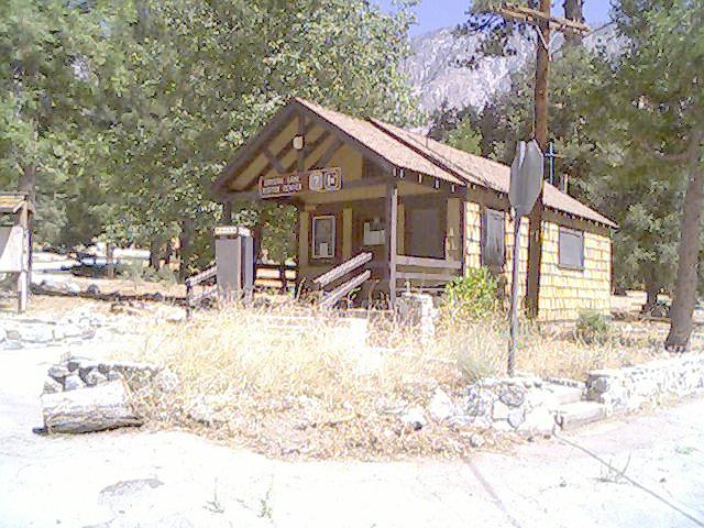
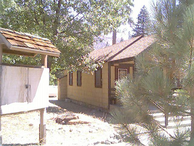
Visitor Centerby Fredric L. Rice Wednesday, Sep. 13, 2006 at 9:47 AMfrice@skeptictank.org
I cleaned this place up, removed the brush, cut back the trees off of the building, repaired the windows. (Someone had broken into the building)
Report this post as:
BBQby Fredric L. Rice Wednesday, Sep. 13, 2006 at 9:47 AMfrice@skeptictank.org
All of the cooking boxes have been sand blasted cleaned.
Report this post as:
Pine 1by Fredric L. Rice Wednesday, Sep. 13, 2006 at 9:47 AMfrice@skeptictank.org
View from Pinyon Ridge 1
Report this post as:
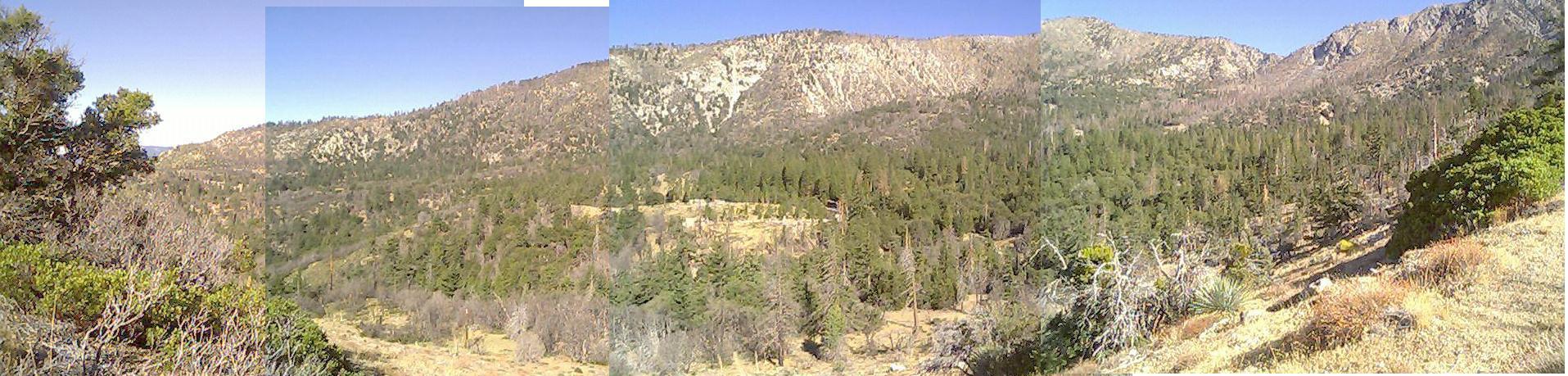
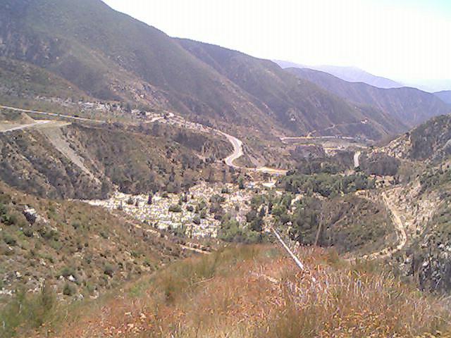
Pan-O-Ramby Fredric L. Rice Wednesday, Sep. 13, 2006 at 9:47 AMfrice@skeptictank.org
A panoramic view of the whole Crystal Lake Recreation Area ravine.
Report this post as:
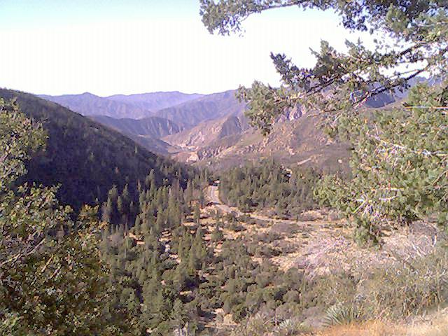
Roadby Fredric L. Rice Wednesday, Sep. 13, 2006 at 9:47 AMfrice@skeptictank.org
Highway 39 heads down to the valley below. The dirt road to the lower right is the abandoned road that cost many millions.
Report this post as:
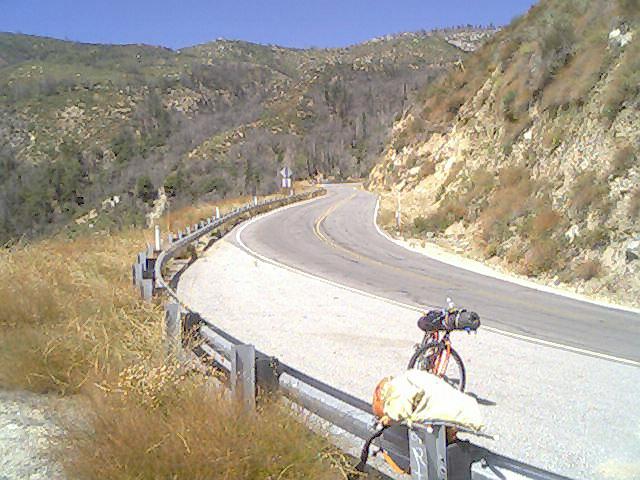
Bikeby Fredric L. Rice Wednesday, Sep. 13, 2006 at 9:47 AMfrice@skeptictank.org
My bicycle and backpack looking up the road.
Report this post as:
Visitor Centerby Fredric L. Rice Wednesday, Sep. 13, 2006 at 9:47 AMfrice@skeptictank.org
The side of the Visitor Center.
Report this post as:
GPS Coordinatesby Fredric L. Rice Wednesday, Sep. 13, 2006 at 9:50 AMfrice@skeptictank.org The view from Pinyon Ridge is located at:
North 34 degrees 19.115 by West 117 degrees 49.901 Altitute 5696 feet. The Panoramic view from Pinyon Ridge is located at: North 34 degrees 19.208 by West 117 degrees 49.809 Altitude 5787 feet
Report this post as:
Pond scumby Quizling Wednesday, Sep. 13, 2006 at 3:06 PMWhy open? the area is thoroughly trashed by grafitti and baby diapers...
The lake, isn't a lake at all. incountry is much better and farther from the untamed lowlanders that frequent the end of hwy 39
Report this post as:
How can people help?by A Wednesday, Sep. 13, 2006 at 4:11 PMDo you have contact info for people who want to help get the park reopened?
Report this post as:
I agree about the trash / Volunteerby Fredric L. Rice Thursday, Sep. 14, 2006 at 5:49 AMfrice@skeptictank.org I agree that the lake is a polluted problem and that re-opening will cause the area -- which is currently clean and pristine! -- will once again get trashed. That's the way it goes for all national parks, alas.
If you would like to help, the San Gabriel Mountain Trailbuilders gather in Azusa, California at the "Ranch Market" that's along Azusa Blvd a.k.a. Highway 39 and they leave to head up to the canyons at 8:00 a.m. sharp the first and third Saturday of every month. I'm not actually with their group; I tag along most of the time and join in the heavy work since it's great exercise and it's an opportunity to enjoy the out doors. Email me for specifics. The Trailbuilders will be gathering this Saturday at the market -- corner of Azusa and Sierra Madre in the parking lot where Bunjee Jumpers also gather every Saturday.
Report this post as:
What did you expect?by Gunny Thursday, Sep. 14, 2006 at 5:57 AMYou and I both know that a month after crystal lake repopens it will look jus like the rest of the US39/east fork area, complete with floating pampers, beer bottle throwing contests and 2,000 watt stereos. I hope you will be able to make peace with with it and yourself. You havn't seen anything yet though.
Report this post as:
All trueby Fredric L. Rice Thursday, Sep. 14, 2006 at 6:49 AMfrice@skeptictank.org I know -- it's why that section along East Fork Road is known as "Pamper Flats." But I don't see as how I personally have any control over it. I'm just a volunteer who's working on re-opening because the trail group does to things that try to mitigate the problems:
Unofficial trails are blocked and official trails and re-opened to try to limit foot traffic to certain areas which also tries to consolidate garbage along known paths. Trails are widened to allow pack horses to be used to cart out garbage, reduce medical emergency calls, and allow access to fire fighters. One of the big problems they had just before the area was closed was gangs fighting and shooting at each other. The Sheriff's office started disallowing people up there based on profiles, and started arresting and releasing people based on profiles. That measure caused legal issues to be raised so closing the area and keeping it closed was a good solution. How they'll handle such problems when they re-open I have no idea -- probably assign a police officer to be on duty all the time, would be my first guess.
Report this post as:
|