| About Us | Contact Us | Calendar | Publish | RSS |
|---|
|
Features • latest news • best of news • syndication • commentary Feature Categories IMC Network:
Original Citieswww.indymedia.org africa: ambazonia canarias estrecho / madiaq kenya nigeria south africa canada: hamilton london, ontario maritimes montreal ontario ottawa quebec thunder bay vancouver victoria windsor winnipeg east asia: burma jakarta japan korea manila qc europe: abruzzo alacant andorra antwerpen armenia athens austria barcelona belarus belgium belgrade bristol brussels bulgaria calabria croatia cyprus emilia-romagna estrecho / madiaq euskal herria galiza germany grenoble hungary ireland istanbul italy la plana liege liguria lille linksunten lombardia london madrid malta marseille nantes napoli netherlands nice northern england norway oost-vlaanderen paris/Île-de-france patras piemonte poland portugal roma romania russia saint-petersburg scotland sverige switzerland thessaloniki torun toscana toulouse ukraine united kingdom valencia latin america: argentina bolivia chiapas chile chile sur cmi brasil colombia ecuador mexico peru puerto rico qollasuyu rosario santiago tijuana uruguay valparaiso venezuela venezuela oceania: adelaide aotearoa brisbane burma darwin jakarta manila melbourne perth qc sydney south asia: india mumbai united states: arizona arkansas asheville atlanta austin baltimore big muddy binghamton boston buffalo charlottesville chicago cleveland colorado columbus dc hawaii houston hudson mohawk kansas city la madison maine miami michigan milwaukee minneapolis/st. paul new hampshire new jersey new mexico new orleans north carolina north texas nyc oklahoma philadelphia pittsburgh portland richmond rochester rogue valley saint louis san diego san francisco san francisco bay area santa barbara santa cruz, ca sarasota seattle tampa bay tennessee urbana-champaign vermont western mass worcester west asia: armenia beirut israel palestine process: fbi/legal updates mailing lists process & imc docs tech volunteer projects: print radio satellite tv video regions: oceania united states topics: biotechSurviving Citieswww.indymedia.org africa: canada: quebec east asia: japan europe: athens barcelona belgium bristol brussels cyprus germany grenoble ireland istanbul lille linksunten nantes netherlands norway portugal united kingdom latin america: argentina cmi brasil rosario oceania: aotearoa united states: austin big muddy binghamton boston chicago columbus la michigan nyc portland rochester saint louis san diego san francisco bay area santa cruz, ca tennessee urbana-champaign worcester west asia: palestine process: fbi/legal updates process & imc docs projects: radio satellite tv |
printable version
- js reader version
- view hidden posts
- tags and related articles
Colorado Basin/Persian Gulf Bioregionalismby Marc Herbst Thursday, Oct. 17, 2002 at 11:03 PMAn amazing art exhibit at Pasadena City College by Peter Fend.
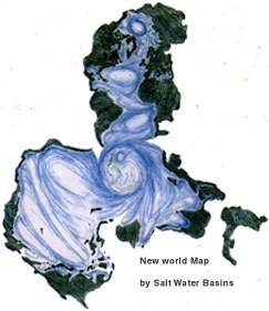
In a visionary display, NYC artist Peter Fend has made a bold challenge to both the Bush Administration and oilopoly by redrawing the world maps not by nation states but by trans-boarder Salt-water basin regions.
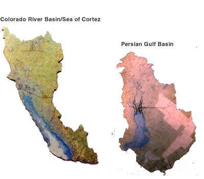
His maps insist upon a global vision that put survival before nationstate and insist by their very vision on a sustainable-non fossil-fuel based global culture. For the show "flow-lines" he presents two maps, a map of the colorado river/sea of cortez basin and the persian gulf basin. "The Peter Fend argues that for a healthy planet, we must start thinking in terms of water basins, not countries. we must understand that a regions most natural allie is a region that it can learn most from- that is- a region with similiar ecosystems and environmental indicators. In comparing and demanding parity between Southern California and its natural ally- the persian gulf- he calls on intense criticism of US government policy. He applauds the water and environmental management that the USSR and Iraq had historically done until their riparian repairs were blown up as a result of American Intervention in the region. Yet, ever the artist- Peter claims that the riparian repair systems were based on a model provided by early american conceptual artists. Critique the Bush administration further still. Peter Fend states that yes, Iraq has weapons of mass destruction. Those weapons are buried under ground in Iraq- it is known as oil. He states that If that oil were to be burned off in accordance with Bush/big oil plans- it would do greater harm to the planet than any weapons of mass destruction that Iraq may have. Peter Fends well thought out bio-centric plans are astounding. He has for the last 20-odd years tried to get his plans instituted on policy level. Yet, despite meetings with the UN, Hugo Chavez, and other political officials, the world seems yet unable to switch from a petroleum based world of Nation States to a sustainable world of River Basins. contact Peter Fend at
Report this post as:
Persian Gulf/ Colorado River- sister river basinsby Marc Herbst Thursday, Oct. 17, 2002 at 11:03 PM
The first image is that of a map with redrawn territories. Each land mass is a seperate water basin. You will note that the map centers around Antarctica- the life pump of the earth's waterways and ecosystems.
Report this post as:
|


