(This article if free of copyright - in the public domain. Anyone may, and is encouraged to, use and distribute if freely.)
The coordinates and other details of the Crawford (Texas) Ranch and other presidential hideouts really are closely guarded secrets. Some of those secrets are disclosed here for the first time anywhere.
Antiwar protests at Crawford, TX, and the president's ranch near there have been tried before. One such attempt was rebuffed by local officials last August. The president is busy making war, but not so busy as to eschew another monthlong vacation at the ranch this year, in August. So the information here, intended to facilitate peaceful protests at the ranch, is timely.
What we are advocating here is to take peaceful protests to the peaceful refuges of the president. Why should his quietude be insured when he is raining "Shock and Awe" on the civilians of various countries?
Last August, people from around Texas converged on Crawford to protest the administration's plans for the war in Iraq. Thousands were expected, but Bush fled to California. Nevertheless, hundreds of protesters turned up in tiny Crawford, including the Texas Green Party candidate for governor, a member of the British Labor Party, and other notables.
http://www.informationwar.org/antiwar_activities/momentum_builds_anti-war_demo_texasaug252002.htm Refusing to pay the police department $300 to exercise their First Amendment rights, they headed out to the ranch. The Crawford police "headed them off at the pass" by blocking the direct route of town. Posses of the Texas Rangers (state police) and McLennan County sheriff set up two road blocks on the road to the ranch, Prairie Chapel Rd., complete with Secret Service agents and helicopters. The sheriff closed this public road on his own authority and with no notice, except that the protesters were coming. Deputies refused to allow the protesters to park and proceed on foot, and went so far as to detour them down another road leading to a state police roadblock. All of this points to the need for logistical information such as that provided here.
In October, a caraval of protesters from the National Coalition for Jobs and Income Support was stopped near Rainey Rd. They proceeded on foot and reportedly got within 30 yards of the ranch entrance. The protest received widespread media attention.
http://www.nationalcampaign.org/crawford.asp Bring the Peace (Movement) to the President
As his armies advance on the on the defenseless people of the world (other races), President Bush retreats to one of the federally protected getaways described here -- who says there's no rest for the wicked? One of these places (the Texas ranch) has already seen peace protests. Another (Camp David) is famous for peace accords. What better venues for peace protests? It might turn out that there is no rest for the wicked after all.
PRAIRIE CHAPEL RANCH (FORMERLY KEN ENGELBRECHT'S HOG FARM) -- WHERE BUSH PRACTICES (SELF-SERVING) CONSERVATION
The FAA's original no-flight zone for the ranch listed the center as 31 deg 34 min 57 sec North and 97 deg 32 min 37 sec West, which is the location of the main ranch house to the nearest second! They later moved this about 3000 ft (0.9 km) east-southeast. However, the actual, precise location of the house is:
latitude 31.58257 degrees (31 deg 34 min 57.25 sec) North, longitude -97.54359 degrees (-97 deg 32 min 36.92 sec) West, altitude 840 ft (256 m) MSL. This is intended only to help you find it on printed and online maps.
See
http://www.eaa.org/communications/eaanews/020924_texas.html for the FAA flight restricition, with the original close-but-not-precise coordinates.
The main house is about 4400 ft (1341 m) north of Rainey Rd. and about 1000 ft (305 m) south of the dense woods along Rainey Creek. Bush removed five large hog barns that were at the point where his drive (the old road, Mill Rd., shown on old topos and aerial photos) bends to the right. He extended the old road about 900 ft (274 m), removing the buildings at the hooked end of the old road and building a new house on a loop at the end of the extension. Another, small, old house remains, about halfway down the drive. It contains exercise equipment. For maps of the hog farm before Bush made these changes, see
http://www.cryptome.org/prez-eyeball.htm The ranch is bounded on the north by Rainey Creek, on the east by the Middle Bosque River, and on the west by a fenceline just west of Mill Rd. You can see the southern boundary as you take Prairie Chapel Rd. up from Crawford. The land totals 1583 acres (641 hectares). The maps (above) show the streams and seven canyons branching from them, lined by dense growths of tall trees. Much of the ranch is sparsely wooded pasture.
The lane to the house (Mill Rd.) goes south to Rainey Rd., which goes west to Prairie Chapel Rd., the road to Crawford, TX. Rainey Rd. is basically Bush's private road.
During construction George and Laura occupied an old ranch house on the southern extension of Rainey Rd. (on the east side of the extension), calling it the "Governor's House." This house is still used as a guest house for White House neoconservatives and other second-tier guests. Across from the Governor's House is a building housing the military aide (bearer of the nuclear weapons codes), doctor, nurse, and White House Communications Agency, which uses buried fiberoptic cables (24-strand) and copper cables (25-pair) for secure communications on the property.
The nearest road to the north is West Middle Bosque Rd. (about 1.25 mi or 2 km). South, between this road and the Bush house, is a large woods on another property. The houses on Middle Bosque are way back on the north side of the road. Rainy Creek and the Middle Bosque River are dry for most of their length, most of the time. A closeup view of the president's famous Texas White House and his favorite refuge (he says, and this we believe -- it is beautiful country) is at
http://usatoday.com/news/washington/2001-04-13-bush-house.htm The April 4, 2001, print edition of "USA Today" shows the same thing.
The highest honor Bush can bestow is a visit here. Few world leaders are invited -- except for war allies whose loyalty is written in blood (of others). This is the dude ranch where the president hopes to escape from his "poor little rich boy" East Coast heritage by assuming his affectations of the Marlboro Man. Natilie Maines (of the Dixie Chicks) needn't be ashamed the president is from Texas -- he isn't. He was born and educated on the East Coast, and his ancestral mansion (see below) is there. Texans endured the son-of-a-carpetbagger as governor and are aware of the charade. Some neighbors liked the smell of the place better when it was a hog farm (I kid you not). The Bushes don't have many close friends around here, except for the Armen F. Weiss family and Ken Engelbrecht, the former owner of the ranch, now reduced to a kind of sharecropper (he owns 200 head of cattle on the ranch).
The new main house is built like a motel but with the porch on the back instead of the front - see closeup graphic in
http://usatoday.com/news/washington/2001-04-13-bush-house.htm The style is that of an office factory, with narrow, high windows and doors at intervals. The house was designed by an "environmental architect." Bush should demand his money back unless he really intends to run a motel. Architect David Heymann should give it back, if he is loyal to environmentalism The house was built by a religious commune from nearby Elm Mott, TX, out of a yellowish-beige native limestone, supposedly so as not to mar the natural landscape (since it's his, not yours). A geothermal heating/cooling system saves energy, a cistern behind the house collects rainwater for watering the lawn (no acid rain out here), and Bush hugs the trees (his, not yours), cutting down mostly water-hungry cedars -- too many ironies here to get into. The house itself is supplied with city water from Crawford. The roof is white metal.
The long, low house faces south. It is about 160 ft (49 m) long. The house is mostly one room wide, like a motel. The eight rooms are spread over a central area and two wings that are angled forward (see graphic). The house totals 4300 square ft (400 sq m.) in three areas, which are, west to east: office/study wing, bedrooms (central area), kitchen/dining room, and living room (east wing, overlooking the lake). Two enclosed porches, "dogtrots," in Texan (for the "dogs of war"?), one between the center and each wing, add about 1100 sq ft (102 sq m). A long open porch on the back and west is about 8 ft (2.4 m) wide. It widens on the east end to cover the patio.
There is also a two-bedroom guest house (1400 sq ft, (130 sq m) for the twins, west of the main house. South of that is a garage/carport, 1400 sq ft (130 sq m).
The government (you) built an approximately 70 x 40 ft house for the SS, hidden by a grove of trees 100 yards (91 m)northwest of Bush's house. What goes around comes around as this place has gone from hogs to "pigs". Attached to one corner is a storage area, approximately 20 x 20 ft, possibly for armaments. The U.S. president is not a man of peace. There are small sentry booths for the SS scattered over the ranch. Owners of the surrounding farms have given the Secret Service access to their property to patrol the perimeter of the Bush ranch.
Bush added a 10-acre (4 hectare) fishing lake east of the new ranch house. It is trapezoidal, with the base toward the west. Not shown is a swimming pool, built on the pleas of his daughters and thus called the "whining pool." Would that the crying of other people's childen, in U.S.-inflicted suffering, could affect him.
Here at the Bates Motel for war criminals (guess who plays "Psycho"?), Bush entertains the likes of Blair (UK), Howard (Australia), and Aznar (Spain), and Silver Lips Burlusconi (Italy). Vladimir Putin (Russia) was a guest, before he threatened to veto Bush's war, but probably would replace the pig as the real guest of honor of the barbecue if he shows up again.
Protester's Approach to Bush's Texas Ranch
Refer to
http://www.terraserver.microsoft.com/image.aspx?t=2&s=15&x=99&y=545&z=14&w=1 This shows the location of the ranch house, a little northwest of the "901 (meters)" elevation label on the above map. It is nestled in the northwest corner of McLennan county.
For labels to the roads shown, run a search for "Mill Rd. Crawford, Texas" on
http://www.mapquest.com Protesters heading for the Bush ranch are routinely harassed by a local posse. Individuals approaching the ranch by car have no problem, though they might be questioned by the Secret Service (SS) if they disobey the orange signs against stopping near the ranch. However, caravans are obstructed by roadblocks of the Crawford city police, Texas Rangers (state police), and McLennan county sheriff, who have been known to detour protestors down deadend roads. This has occurred on Prairie Chapel Road, the road from Crawford. Other approaches, as shown, are from Valley Mills on the north and Coryell on the west. Since Valley Mills is in Bosque county and Coryell is in Coryell county, a good plan would be to use the network of roads in these neighboring counties to avoid the Crawford police and the McLennan county sheriff. It would be wise to become familiar with nearby roads in all three counties.
Driving Directions from Gatesville, Texas (from west, recommended): 1: Start out going East on US-84/TX-36 BR/US-84 E toward S 14TH ST. Continue to follow US-84 E. 1.74 miles 2: Turn LEFT to take the TX-36 ramp. 0.03 miles 3: Stay straight to go onto ramp. 0.29 miles 4: Merge onto TX-36. 2.19 miles 5: Turn SLIGHT RIGHT onto FM 929. 10.22 miles 6: Turn LEFT onto CR-262. 1.09 miles 7: CR-262 becomes CREEK 262. 0.07 miles 8: CREEK 262 becomes CORYELL CITY RD. 0.76 miles 9: Turn LEFT onto CANAAN CHURCH RD. 0.15 miles 10: Turn RIGHT onto PRAIRIE CHAPEL RD. 1.68 miles 11: Stay straight to go onto RAINEY RD. 0.81 miles. (PRAIRIE CHAPEL RD. turns right. Don't take it.) RANCH is on north side of RAINEY RD, at MILL RD.. Total distance is 19.04 miles. Don't expect to get all the way to Mill Rd., especially in a caravan.
Drivng Directions from Crawford, Texas (from east) 1: Start out going West on 5TH ST/FM 185 toward TX-317/LONE STAR PKWY/AVENUE G. 0.33 miles 2: Turn RIGHT onto N AVENUE B. 0.08 miles 3: Turn LEFT onto W 4TH ST. 0.07 miles 4: Turn SLIGHT RIGHT onto PRAIRIE CHAPEL RD. 7.58 miles 5: Turn RIGHT onto RAINEY RD. 0.81 miles. RANCH is on north side of RAINEY RD, at MILL RD. Total distance is 8.88 miles. Don't expect to get all the way to Mill Rd., especially in a caravan.
Trails and drives crisscross the ranch. Bush uses these for his 7 a.m. jogging and showing the place to his fellow war criminals. The maps show a canyon along Rainey Creek, about halfway from the house to the Middle Bosque River. Bush spends a lot of his famous long vacations clearing trees from canyons (a total of seven).
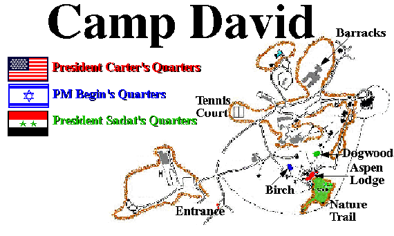
CAMP DAVID -- BUSH'S "EAGLE'S NEST," WHERE WAR PLOTS ARE HATCHED
The president goes here on weekends, after a hard week's work plotting The Perpetual War (against terrorism, for oil, for votes, for Mother and Wimp). This is his favorite spot on Christmas day. One can find pictures of his dad, Bush the First, holding Jenna and Barbara (Bush the Second's daughters) in front of the tree. These pictures are about as heartwarming as pictures of Hitler holding children while sending other children (other races) to the gas chambers. You can probably even find pictures of Hitler holding children at his mountain retreat, the "Eagle's Nest" or Berg Hof (Mountain House), near Berchtesgaden (finding parallels with der Fuhrer and the Burlusconi-like Mussolini makes a fun parlor game).
Camp David is on top of and on the east slope of Catoctin Mountain in central Maryland. The details of it are considered a state secret. Posting a map of it on the Internet invites inquiry from the SS (Secret Service, in this time and place), even though it is in every U.S. library on page 323 of Jimmy Carter's book "Keeping Faith: Memoirs of a President," Bantam Books, 1982. The book is about peace negotiations between Egypt and Israel. Right now, it's peace demonstrations that are needed there.
A Government map that gives an overall view of the area is at
http://www.lib.utexas.edu/maps/united_states/camp_david_1971.jpg where Camp David is shown as "Camp 3" in the upper-left corner. (This was before FDR took over the camp.)
For a map of Camp David itself, see:
http://www.ibiblio.org/sullivan/maps/CampDavid-map.GIF For a more detailed view of this, see page 323 of the Carter book.
For driving purposes, the National Park Service map at
http://www.nps.gov/cato/ppmaps/catomap1%2Epdf shows the Catoctin Mountain National Park, which is mostly public except for Camp David. To get there, take U.S. 15 to Thurmont, MD. Go west on state highway 77 along Hunting Creek. At the Catoctin Mountain Park visitor center, turn right onto Park Central Rd. This road goes north, then west to the entrance of Camp David. Camp David is at the "1880 ft" elevation label on the map.
When the Leader or Vice-Leader is present, nearby park roads are closed. At other times, even though the secretary of war or other cabinet members are likely present, all park roads and trails are open. Park Central Road runs about 1300 feet (396 meters) from the front gate of Camp David. From the road, you can catch a glimpse of the high -- 10-foot (3 m) -- security fence, which one day should remind Mr. Bush of the UN detention center at The Hague.
The president's residence is Aspen Lodge, at latitude 39.64736 degrees (39 deg 38 min 50.49 sec) West, longitude -77.46304 degrees (-77 deg 27 min 46.94 sec) North, and altitude 1822 ft (549 m).
The map datum is the NAD-83/WGS-84, used on modern American maps. The altitude is of course referenced to MSL, mean sea level. Your civilian GPS is not nearly as accurate as the above coordinates, on purpose.
Aspen Lodge (the president's residence) is about 1000 ft (300 m) from Park Central Road and about 1.5 mi. (2.5 km) from Maryland highway 77 and about 1.25 mi (2.0 km) from highway 550 (both public, always open). The high point of the mountain is just west, "Highpoint," at an elevation of 1880 ft (573 m).
Aspen Lodge is a frame building with two wings forming a 30-degree angle. It has three areas -- bedrooms, living room, kitchen -- with three areas in the basement, separated by 8-inch (20 cm) walls. The house faces a golf green on the east. There is a swimming pool on the south, shaped like a magnifying glass with a fat handle. For an artist's rendition of the lodge, see
http://www.mongiello.org/images/aspenxmas.jpg which shows a rear view (from the east) of the lodge.
Since the lodge is on the east slope, it has a good view to the east and southeast, overlooking the beautiful Monacacy Valley. The field of vision works both ways, so the lodge should be visible with optical aids along stretches of U.S. highway 15 between St. Anthony, MD, on the north, and Creagerstown Station, MD, on the south. See
http://www.topozone.com/map.asp?lat=39.61539306097943&lon=-77.39225728444276&size=m&symshow=n Kleig floodlights or searchlights -- perhaps colored, shaped to form a "V" for peace, or configured like the Ground Zero colums of light -- could send a visual reminder of wars and questions about 9/11 to the Eagle's Nest. Some communities have regulations governing kleig lights, such as requiring that the lights be used at an angle no more than 30 degrees from perpendicular. Obviously we are not proposing beaming these toward anyone.
There is an old abandoned road leading from Camp David down the north slope. There is a railroad (the Maryland Midland, ex-Western Maryland) along highway 550. There is also a creek along 550 with a branch up the mountain to within about 1200 ft (367 m) from Blue Ridge Summit overlook. It is beautiful country.
WALKERS POINT, MAINE, WHERE "W" REALLY COMES FROM
President Bush is NOT from Texas: Natalie Maines and the good people of that state can rest easy. Technically, he is an Eastern Establishment figure; but as you will see, there is nothing to brag about.
The current president was born in New Haven, Connecticut, and his roots are so-called "upper crust" New England (really just "new dough"). The family home, occupied by Bush I and Barbara from June to October, is near the Atlantic Coast town of Kennebunkport, Maine, on a peninsula shown on the maps that follow. The father of the current president's grandmother (father of Dad's mother), George Herbert Walker, bought the peninsula and built the enormous brown-shingled house shown in the photo.
http://www.ipipublishing.com/images/travel_edit.pdf He somewhat immodestly named the peninsula "Walker's Point," and the family has somewhat immodestly always called the house the "big house." If Bush doesn't make it to The Hague for international crimes, he should make it to the real Big House as his domestic crimes are exposed.
Supposedly Bush II shies away from jogging on Ocean Avenue when visiting Mother and Dad, since this would involve shutting down the street and bothering the uppity neighbors -- and this is the guy who brought Shock and Awe to Bagdad, a city of 5 million.
Of course "Dubya" also got his famous initial from Walker.
Walker left the property to his son Herbert Walker, who sold it to then-vice-president George Herbert Walker Bush, or Bush I, in 1981. Now you know how G.H.W. Bush got his middle names as well as his house (and why his "W" doesn't stand for "Wimp" after all).
The current Bush, Dubya, has been trying to live down his rich (monetarily only) past and Dad's wimpish image to portray himself as another Marlboro Man, for power, self-enrichment and Mother, of course.
The Bushes are really much more interesting than the Walkers. Especially interesting is the president's grandfather, the notorious graverobber Prescott Sheldon Bush. Prescott Bush was born in 1895 in Columbus, Ohio -- these people aren't old-line New Englanders either, just drifters and opportunists. (Prescott Bush had a son of the same name, not discussed here.)
Prescott Bush, Bush I's father, is noted for desecrating the grave of Native American leader Geronimo in 1918, at Ft. Sill, Oklahoma.
http://www.daghettotymz.com/rkyvz/articles/skull&bones/s&b1.html He and four or five other soldiers at Ft. Sill robbed the grave, and Bush eventually took the bones to Yale University, where they were put on display and used for rituals in a secret society Bush belonged to, the Skull and Bones Society. Presumably they remain there. The Bushes and Ft. Sill deny the robbery, the Indians believe in it, but it has never been investigated much. If you want to raise Dubya's blood pressure, just ask him about Skull and Bones (blows his cover).
Among those in the U.S. power structure who inherited rather than worked for their station in life, a large number are former members of S&B from wealthy East Coast families. Both Presidents Bush are Skull and Boners. George W. Bush is an Eastern Establishment figure, not a Texan. He was born in Connecticut. His dad moved the family to Texas when Dubya was two. He attended the Phillips Academy prep school in Massachussetts (at age 15) and Yale University (until age 22). He took an MBA from Harvard at age 29 and returned to Midland, TX. The ancestral family home (Dad's) is in Maine (George and Barbara have another in Houston). Dubya is living a lie for power and money. Remember: Eastern Establishment, not a Texan.
Prescott Bush is also infamous as one of Hitler's financiers. In 1942, under the Trading With the Enemy Act, the U.S. Government seized several companies in which he had an interest. Bush at the time was an investment banker with Brown Brothers Harriman (BBH), which had funneled U.S. capital into Germany during the 1920s and 30s, when Hitler was rising to power. Among the seized companies was the Union Banking Corporation (UBC) of New York, which was controlled by German industrialist Fritz Thyssen. Thyssen had been an early financier of the Nazi party -- in fact, in 1941 he published a book entitled "I Paid Hitler." The U.S. government has more proof about Prescott Bush than it does about Saddam Hussein (another admirer of Hitler). Also, Prescott Bush got $1.5 million for his share of UBC when it was liquidated in 1951. George Bush has money and power, but I at least can be proud of my grandparents.
Imagine if the Jukes and the Kallikaks got WMD and control of the government and you can see what we are up against. Bushes committing outrages against people of other races and ethnicities and promoting fascism: some things stay the same -- but they are getting closer to home.
For aerial photos of the area, go to:
http://www.skypic.com/images/7-4022.jpg Bush's house is on the green (grass), just above the "Walk" of the "Walkers Point" label.
For a highway map, enter the coordinates of the "big house," lat. 43.34280 deg N, longitude -70.45963 W, at:
http://www.mapquest.com or
http://www.mapsonus.com Driving Directions from Points South (Boston, etc.) As You Enter Maine, Just After Portsmouth, NH,
(George and Barbara's place is hard to find; so the following directions and accompanying map will be very helpful):
Miles Total Miles
0.0 mi Start Point (I-95, Portsmouth, NH) Head NORTH-EAST on I 95.
3.9 mi FOLLOW as road goes into I 95 (NORTH) [MAINE TPK] 3.9 total miles
19.2 mi BEAR RIGHT onto SANFORD RD [HWY 109 (EAST)] 23.1 total miles
1.0 mi CONTINUE onto HWY 9 (EAST) [HWY 109 (EAST)] 24.1
0.4 mi CONTINUE onto SANFORD RD [HWY 109 (EAST)] 24.5
0.7 mi TURN LEFT onto US 1 (NORTH) [BLUE STAR MEM. HWY] 25.1
1.8 mi BEAR RIGHT onto PORT RD [HWY 9 (EAST)] 26.9
0.9 mi FOLLOW as road goes into WELLS RD [HWY 9 (EAST)] 27.8
1.4 mi FOLLOW as road goes into WESTERN AV [HWY 9 (EAST)] 29.2
0.7 mi CONTINUE onto WELLS RD [HWY 9 (EAST)] 29.9
0.4 mi CONTINUE onto WESTERN AV [HWY 9 (EAST)] 30.3
1.1 mi BEAR RIGHT onto OCEAN AV 31.4
0.3 mi FOLLOW OCEAN AV as it TURNS RIGHT 31.7
1.1 mi FOLLOW OCEAN AV as it TURNS RIGHT 32.8
Less than 0.1 mi FOLLOW OCEAN AV as it TURNS RIGHT 32.9
0.2 mi FOLLOW OCEAN AV as it BEARS RIGHT 33.0
0.2 mi End Point: Summit Av (on left), Kennebunkport, ME
George and Barbara's drive is another 0.3 to 0.4 mi farther, on the right. Tell 'em "hey."
(This article is free of copyright - in the public domain. Anyone may, and is encouraged to, use it freely.)